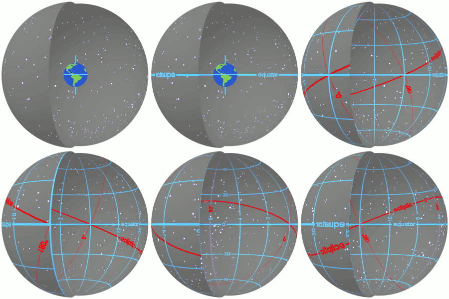
Declination
Declination (DEC) is an astronomical term that refers to one of the two coordinates used in the equatorial coordinate system to determine the position of a point on the celestial sphere. The declination of an object is the angle between the equatorial plane and the line from the center of the Earth to the object. It is analogous to latitude on the Earth's surface, measuring north or south of the celestial equator. Declination is measured in degrees (°), minutes ('), and seconds (), with positive values indicating north of the celestial equator and negative values indicating south.
Overview[edit | edit source]
The concept of declination is crucial in the field of astronomy for accurately locating objects in the sky. Along with right ascension (RA), declination forms the equatorial coordinate system, which is based on the Earth's rotation axis and equator. This system allows astronomers to specify the location of celestial objects regardless of the observer's location on Earth or the time of observation.
Measurement[edit | edit source]
Declination is measured in degrees, from +90° at the celestial north pole, through 0° at the celestial equator, to -90° at the celestial south pole. For example, a star with a declination of +20° is located 20° north of the celestial equator. The measurement of declination is independent of the observer's location and the Earth's rotation, making it a stable coordinate for identifying the position of celestial objects.
Importance in Astronomy[edit | edit source]
Declination, along with right ascension, is essential for the mapping and tracking of celestial objects. It is used in various astronomical calculations and observations, including the planning of telescope observations and the navigation of spacecraft. Understanding declination is also crucial for amateur astronomers in aligning telescopes and finding objects in the night sky.
Related Concepts[edit | edit source]
- Celestial coordinate system: The system used to specify positions of celestial objects. It includes other coordinate systems such as the horizontal coordinate system.
- Right ascension: The other coordinate used in the equatorial system, measuring eastward along the celestial equator from the vernal equinox.
- Celestial equator: The projection of the Earth's equator onto the celestial sphere, serving as the reference plane for declination.
- Celestial poles: The points where the Earth's axis of rotation, extended infinitely into space, intersects the celestial sphere.
See Also[edit | edit source]
Search WikiMD
Ad.Tired of being Overweight? Try W8MD's physician weight loss program.
Semaglutide (Ozempic / Wegovy and Tirzepatide (Mounjaro / Zepbound) available.
Advertise on WikiMD
|
WikiMD's Wellness Encyclopedia |
| Let Food Be Thy Medicine Medicine Thy Food - Hippocrates |
Translate this page: - East Asian
中文,
日本,
한국어,
South Asian
हिन्दी,
தமிழ்,
తెలుగు,
Urdu,
ಕನ್ನಡ,
Southeast Asian
Indonesian,
Vietnamese,
Thai,
မြန်မာဘာသာ,
বাংলা
European
español,
Deutsch,
français,
Greek,
português do Brasil,
polski,
română,
русский,
Nederlands,
norsk,
svenska,
suomi,
Italian
Middle Eastern & African
عربى,
Turkish,
Persian,
Hebrew,
Afrikaans,
isiZulu,
Kiswahili,
Other
Bulgarian,
Hungarian,
Czech,
Swedish,
മലയാളം,
मराठी,
ਪੰਜਾਬੀ,
ગુજરાતી,
Portuguese,
Ukrainian
Medical Disclaimer: WikiMD is not a substitute for professional medical advice. The information on WikiMD is provided as an information resource only, may be incorrect, outdated or misleading, and is not to be used or relied on for any diagnostic or treatment purposes. Please consult your health care provider before making any healthcare decisions or for guidance about a specific medical condition. WikiMD expressly disclaims responsibility, and shall have no liability, for any damages, loss, injury, or liability whatsoever suffered as a result of your reliance on the information contained in this site. By visiting this site you agree to the foregoing terms and conditions, which may from time to time be changed or supplemented by WikiMD. If you do not agree to the foregoing terms and conditions, you should not enter or use this site. See full disclaimer.
Credits:Most images are courtesy of Wikimedia commons, and templates, categories Wikipedia, licensed under CC BY SA or similar.
Contributors: Prab R. Tumpati, MD


