Geomorphology
Geomorphology is the scientific study of the origin and evolution of topographic and bathymetric features created by physical, chemical or biological processes operating at or near the Earth's surface. Geomorphologists seek to understand why landscapes look the way they do, to understand landform history and dynamics, and to predict changes through a combination of field observations, physical experiments, and numerical modeling. Geomorphology is practiced within physical geography, geology, geodesy, engineering geology, archaeology, and geotechnical engineering. This field of study is closely related to soil science, hydrology, environmental science, and other aspects of the Earth sciences.
Overview[edit]
Geomorphology translates to "the study of earth forms." It is concerned with the classification, description, and the origins of landforms such as mountains, valleys, plains, and deltas. The discipline is divided into several sub-disciplines based on the processes that create the landforms, including fluvial geomorphology, glacial geomorphology, coastal geomorphology, aeolian geomorphology, and tectonic geomorphology.
Fluvial Geomorphology[edit]
Fluvial Geomorphology focuses on the processes related to rivers and streams and the deposits and landforms created by them. It is concerned with the way water interacts with the landscape to shape it, including the formation of meanders, floodplains, and deltas.
Glacial Geomorphology[edit]
Glacial Geomorphology studies landforms created by the action of glaciers, such as U-shaped valleys, fjords, and moraines. It examines the processes of glacial erosion and deposition as well as the climatic conditions that allow glaciers to form.
Coastal Geomorphology[edit]
Coastal Geomorphology is concerned with the landforms of coastal regions and the processes that shape them, including wave action, tidal processes, and sea level changes. Features of interest include beaches, cliffs, sand dunes, and barrier islands.
Aeolian Geomorphology[edit]
Aeolian Geomorphology focuses on landforms created by the wind, such as dunes and loess plains. It studies the processes of wind erosion, transport, and deposition of sediment.
Tectonic Geomorphology[edit]
Tectonic Geomorphology examines the influence of tectonics on the Earth's surface and its landforms. It studies the topographic and bathymetric features that result from tectonic forces such as earthquakes, volcanic activity, and mountain building.
Techniques and Methods[edit]
Geomorphologists use a variety of techniques to study the Earth's surface including remote sensing, field observations, and numerical modeling. Remote sensing allows for the analysis of landforms at a large scale and over long time periods. Field observations are crucial for understanding the processes that create and modify landforms. Numerical modeling is used to predict future changes to the landscape.
Applications[edit]
The study of geomorphology has practical applications in hazard assessment, environmental management, and in the planning and design of infrastructure. Understanding the processes that shape the landscape can help predict and mitigate the effects of natural disasters such as floods, landslides, and earthquakes.
See Also[edit]

-
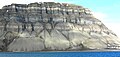
 Badlands at the Blue Gate, Utah
 -
 Earth surface NGDC 2000
 -
 VU0K1843
 -
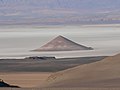 Cono de Arita, Salar de Arizaro (Argentina)
 -
 Velké Hincovo pleso
 -
 God's Window, Mpumalanga, South Africa
 -
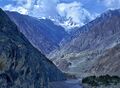 Nanga Parbat Indus Gorge
 -
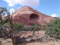 Moab Alcove
 -
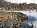 Beaver dam in Tierra del Fuego
 -
 Eroding Mesas Forming Seif and Barchan Dunes in Hellespontus region
 -
 Glacial landscape
 -
 Talus Cones Isfjorden


.jpg)
.jpg)


Medical Disclaimer: WikiMD is for informational purposes only and is not a substitute for professional medical advice. Content may be inaccurate or outdated and should not be used for diagnosis or treatment. Always consult your healthcare provider for medical decisions. Verify information with trusted sources such as CDC.gov and NIH.gov. By using this site, you agree that WikiMD is not liable for any outcomes related to its content. See full disclaimer.
Credits:Most images are courtesy of Wikimedia commons, and templates, categories Wikipedia, licensed under CC BY SA or similar.
Translate page: - East Asian
中文,
日本,
한국어,
South Asian
हिन्दी,
தமிழ்,
తెలుగు,
Urdu,
ಕನ್ನಡ,
Southeast Asian
Indonesian,
Vietnamese,
Thai,
မြန်မာဘာသာ,
বাংলা
European
español,
Deutsch,
français,
Greek,
português do Brasil,
polski,
română,
русский,
Nederlands,
norsk,
svenska,
suomi,
Italian
Middle Eastern & African
عربى,
Turkish,
Persian,
Hebrew,
Afrikaans,
isiZulu,
Kiswahili,
Other
Bulgarian,
Hungarian,
Czech,
Swedish,
മലയാളം,
मराठी,
ਪੰਜਾਬੀ,
ગુજરાતી,
Portuguese,
Ukrainian
